“It was a beautiful stream.” E-mailed John Burnley, nature photographer from Riverhead. Of course, beauty is in the eye of the beholder so John’s statement is debatable.
Our local Native Americans were surrounded by beauty and perhaps didn’t think of the creek that way. They saw the creek as a route of passage to their winter quarters in Dix Hills. Their idea of beauty was the rich food resources and clean fresh water it provided.
I venture to say that today, there are not many places where the public have the opportunity to experience its beauty. Hawley Lake certainly qualifies. As a village park, it is caught between Route 231. Besides the dam and falls at its southernmost end, there is a trail around the lake with a few observation points. During the summer, Hawly Lake has a profusion of white lily pads, swans, and Canada geese.
The lake has always been beautiful. Early residents remember it as a fishing spot. Trout were stocked each spring. A favorite spot was at the dam where “salters” (fish that can live in fresh and salt water) were prized. The lake was much wider and afforded more access. Both the eastern and western banks were filled to provide road bed for 231. The southern end of the lake was extensively filled when Montauk Highway lanes were widened and straightened. Those visiting the park now will hear the constant din of traffic. The lake was become shallower. Sediment from upstream especially during heavy rain events have flowed into the lake. White water lily is called an emergent aquatic plant. It grows in water that is only 4 – 5 feet deep. A thick layer of mud lies on the bottom.
85 year old Darrel Ford remembers the lake in the old days. “ I remember walking across the lake when it was dry. The dam was being rebuilt at that time. There were less trees along the edges.”
Old timers remember trapping muskrats. Today, the muskrats are gone. The banks have changed where muskrats live. The beauty of the creek includes the wildlife along it. As more private homes were built along the creek and embankments of fill were dumped for 231, prior habitats have disappeared.
There was a charming wood bridge across the lake built by Hawley. The bridge was strong enough for cars. It was a crossing from Islip Town to Babylon Town and ended where George Street dead ends. Locals called the eastern side of the lake “Ease Babylon.” The view from the middle of the bridge offered a chance to view the lake and appreciate its beauty. Gus Fishel remembers a trail just east to Cooper Street that offered a walk along the edge of the lake.
Fishel remembers viewing the creek from Deer Park. “ I met with a client and recall seeing the creek much wider than today. It had a good flow of water. It gushed” Today, it is only has a trickle. Trees have taken root because the water level has dropped. The creek isn’t visable any more. Industrial developments have pushed parking lots over the wetlands which are about 20 feet down. Tim Fitwal lived on Brookdale Avenue. He remembers building and playing on rafts, fishing, and swimming in the creek as a kid. “There were forests that we wandered in.” I met Tim at Birchfield Towen Park one day. He showed me a black and white photo of the creek taken through the woods. “This was my spirit place.” He was lucky to have the chance to play and grow up with natural places as his playground. As an adult, he founded a band and called it “Sampawams Creek” attesting to the fact that he had grown up with the freedom to explore and discover right in his back yard.
Today, homeowners who have the back of their yards on the creek have their own private beauty as well as extra privacy. Many have altered the fragile wetland edges by building bulkheads.
John VanBourgandine remembers swimming in the creek north of the golf course. “There were logs across the stream that we could dive off.” At that time, the creek was deep enough to do this. Today, the water depth is 12-18 inches.
Deer Lake, when it is full, is a beautiful place…for homeowners who live on it. There is access for the public at one small place just north of Southern State Parkway.
Sometimes, during a drought, the lake is dry and its beauty dries up with it…a mud hole of cracks.
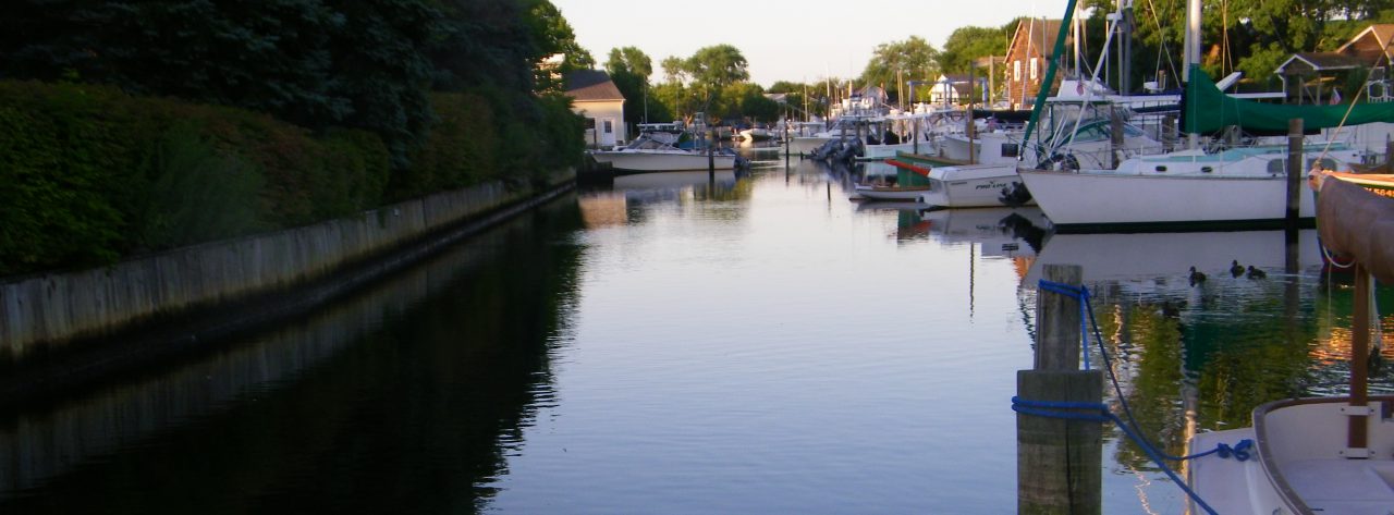
South of Montauk Highway, Sampawams Creek has two faces. On the Islip side, most back yards end in bulkheads. However, there is one boat house that still adds a bit of charm. The Babylon side is bulk headed and has over a hundred boat slips. Walkers can enjoy the beauty of broad stretches water. The municipal dock is popular place to see the great expanse of the Great South Bay and even the seven second flash of theFire Island Lighthouse beam.
The first place I found as I explored for places to find some Sampawams beauty is at the Village golf course, a facility whose name includes “At Sampawams Creek” after looking at a map, The creek touches the fourth fairway. On a walk along the east side, I found tall reeds crowding the grass. Suddenly, an opening in the reeds. The creek! It meandered reflecting tree branches. It’s banks however, had stray golf balls.
After two years of exploring the creek, I found what probably, for me, the most beautiful place of the creek. It is north of a soccer field in Islip Town and the north end of Higbie Lane. If you walk across the Town of Islip recreation field toward Southern State Parkway, you will come to a cattail marsh. Although the sounds of cars rushing by disrupts the experience, it is almost unbelievable that such a place of beauty, largely unnoticed. Teenage youths use a secluded place as a hang out. They’ve left a huge mess.
Early maps show a small pond where the cattail marsh is now. Mud from up creek has deposited over decades creating an ideal habitat for cattails. Unfortunately, another nonnative plant has found this place as well. It outcompetes with cattails. I have a few volunteers who are helping me remove purple loosestrife. I call our small group “The Creek Keepers.” We are determined to provide room for the cattails to expand and fill in the habitat. Redwing blackbirds next here.
Although the beauty spots have diminished, the creek is a resource for us all to enjoy. On the one hand, it forces us to admit, that we don’t appreciate it’s beauty until it is gone. There is a saying that goes. “If you can see it, you own it.” All of our parks and open spaces are examples of this.
How did the beauty slip away? Why does the Carl’s River Greenbelt, just to the west of Sampawams Creek, still exist? Sampwams Creek serves as a boundary line between the two towns. Over decades, it has slipped through our hands. Developers bought land on either side of the creek and sold lots. Buyers were attracted to the
“ Theres’ a creek in our backyard!” The creek happened to be in the way of the expansion of a bypass for cars from North Babylon to Babylon. That’s progress for cars at the expense of a once beautiful natural resource for all of us. Where can the youth of today have a creek? If we “can’t see it, we don’t own it.” A few teenagers have found their place to be alone for fires, drinking, and perhaps drugs.” These young people are good candidates for the Creek Keepers Corps.
Leave a Reply